Ohio Builds Out its Smart Road in the Beta District
By Bruce Edwards
By the end of next summer, sensors on a 35-mile stretch of highway in Ohio could be providing real-time road, weather and traffic data to the state.
The Ohio Department of Transportation is upgrading its Smart Mobility Corridor with high-capacity fiber-optic cables that connect to embedded and wireless sensors -- a new network that ODOT officials say will ultimately provide data to researchers and traffic monitors.
The corridor runs along U.S. Route 33, a four-lane, limited-access road in Ohio. Gov. John Kasich announced a $15 million investment to install advanced highway technology and make the corridor into a “proving ground” for autonomous and connected vehicles. Installation is slated to begin in May and last through the summer.
“Initially, we are going to outfit that corridor with fiber” from Dublin to the East Liberty-based Transportation Research Center, an independent automotive proving ground, ODOT Chief Engineer Jim Barna told GCN. ODOT plans to attach the sensors to the fiber that will facilitate communication between the infrastructure and vehicles. “It will also serve as a testing location for any type of fully automated vehicle,” he added, and effectively serve as an open-road laboratory.
This means research and manufacturing facilities would be able to test their smart transportation technologies on a road through both rural and urban terrain in all four seasons. The route already hosts testing with auto manufacturers and suppliers, including the Transportation Research Center, which is a partner in this project.
ODOT is also considering piloting this technology with part of its own fleet, which travels about 14 million miles a year and includes more than 4,000 vehicles like snow plows, maintenance and freeway service vehicles, Barna said. Data collected from the state’s fleet could then be shared with other connected vehicles on the road.
The collected data would result in more frequent and accurate information about traffic, congestion, weather and surface conditions, which the agency can use for traffic management operations and incident management improvements.
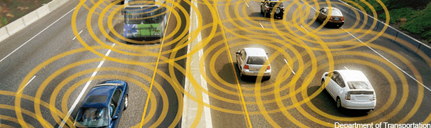
For example, if a connected vehicle hits a patch of black ice and the tires slip, the information would be sent to ODOT, which could then quickly dispatch a salt truck. Sensors detecting sudden temperature drops or a reduction in speed indicating traffic congestion could pass the information to vehicles. Along with vehicle-to-infrastructure information sharing, this technology facilitates vehicle-to-vehicle communication, which could send warnings directly to drivers about incidents related to nearby vehicles or traffic.
According to Barna, ODOT also could use some of the information gathered from this corridor as it looks to outfit future test sites around the state. The state’s own investment has been met with a federal grant of $6 million to Dublin, Marysville and Union County from the Transportation Department to expand fiber-optic networks that connect to U.S. Route 33.The funds are also intended for highway sensors and equipping government vehicles to send and receive data.
ODOT officials plan for the Ohio Turnpike’s existing fiber-optic network to become the center of a connected interstate test corridor that will run from New York to Detroit and Chicago. Eventually, Barna said, the sensors will be able to collect data from all connected vehicles driving on the corridor. In the meantime, ODOT is looking to test the technology, identify and address any problems as state vehicles go “online.”